Live Track - Past 90 daysDistance Sailed to date - 15,383Nm
Download Email Maximum of 160 characters and you cannot include images, as this is a Short Message Service only. Download
Download our track Email us OffShore SMS us OffShore Download GoEast tracks

Wednesday, March 9, 2016

North Brother - Getting the Picture

North Brother is neither instruction nor directive but a rather large hill. It dominates the Laurieton landscape and it visible for miles and is likely responsible for our GPS's, phones and TV all struggling a to obtain a signal. It's big enough to offer plenty of interference and almost demands to be ascended. It's also known as 'Big Brother', being the larger of a cluster of tall hills and named thus, by local Aboriginal tribes (albeit in their own languages).


A cloud halo around our target.

The Bloke just knew he'd be expected to make the trip and offered no resistance. In fact, we made a proper outing of it by encouraging the crews from two catamarans (Bryan and Rowena -Schools Out and Doug and Jeanette -Reeflection) that were anchored nearby, to join us.

To start with, we were all smiles.

We picked up a couple of long sticks and off we went. 

 
The going got quite steep.
 
A couple of stops to catch our breath.
 
Checking the boat part way up.

 
 The trees just got bigger and bigger.
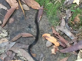
 

Luckily, The Bloke didn't see this critter at all and must have stepped over it. He wasn't shown this picture until we'd come down because he'd have called a taxi to bring him down from the lookout. Just not keen on snakes. I was lucky to spot it on the path in front of me. It was only as thick as your finger. The conventional wisdom that stomping and making lots of vibrations on the ground didn't work on this occasion. No amount of ground thumping was budging this slippery customer and it even reared up. So I stood very still and hoped it would just get on it's way. The best it did was to poke it's head under the leaves. Tired of waiting and reluctant to step over it, I used my 2m long walking stick that I'd picked up at the base of the hill, to flick it out of the way. Needs must!

Last little bit at the lookout.

The Bloke dripping wet from the effort.

 Looking down the Camden Haven River towards the ocean bar.

 Looking south towards Crowdy and Diamond Heads.

 Made it!
 

It was pretty much up, up, up from the bottom of the hill to the summit - 487m, and quite strenuous. The view from the look-out at the summit was worth every step.

Tuesday, March 8, 2016

Leg 60 Tuncurry to Camden Haven - Laurieton

Having misjudged the importance of accounting for 'over-run' on arrival at Tuncurry, we were not going to make that mistake again. We waited until the current would be slack but tide running-in so that (a) we could easily get off the jetty; (b) not be sent hurtling towards the bridge; and (c) have a smooth ride out across the bar. No point having a fright and not learning anything by it.

 The Bloke was happy to leave this jetty.

... and to avoid this hulk on the way out too.

Wired for sound and meaning business!
Our Life Jackets are always on in open water and they are compulsory when crossing a bar.

Waiving goodbye to the Forster-Tuncurry Marine Rescue.

This trip was only a short 15nm and we were able to get to the next bar at the Camden Haven River both in daylight and before the tidal run was adverse. Oh yeh, these River Ocean Bars have our full attention!

Luckily there are web-cams positioned on all the major NSW river bar crossings and they are very helpful and of course a huge boost to safety. We nervously referred to the web-cam several times to double and triple check that the 'coast was clear'. Everyone loves to tell war stories and we'd been given plenty of advice.

Applying all our newly acquired learnings, we had a relatively 'unexciting' bar crossing until the moment our chart plotter threw a wobbly just as we reached the channel and actually plotted us on land! The iPad iNavex App also couldn't get a GPS fix and we resorted to a combination of "eyes up", the maps in the Cruising Guide and Navionics on the iPhone. There are some tight bends to follow the navigable channel along the river, so we constantly double checked the Port and Starboard markers and confirmed with each other that we were passing on the correct side. We were more than a little relieved to spot the Laurieton United Services Club which was our shoreline landmark of where to anchor. For future reference, we'd pick a spot a little further upstream and towards the Southern bank where the tidal run is less intense.

The Laurieton United Services Club.
Poker Machines are very profitable!

A busy moment on the river. The LUSC Jetty is full and Marine Rescue were on patrol.

 Lazy pelicans hoping for some scraps at the fish cleaning table.

 
Tranquility. Let's stay a week!

Sunday, March 6, 2016

Tiny Look at Tuncurry-Forster

Our stay at Forster/Tuncurry was only 2 nights and Heather at the Fish Co-Op, seemed a little disappointed when I went in to pay for only 2 nights. We arrived on a Saturday and our 'mini- jetty' was adjacent to a waterside park and picnic area. While this was quite an attractive spot and we did benefit from the use of the BBQ facilities the next night, Saturday night was a different experience. The usual afternoon crowd of families and retirees was replaced in the evening by drunks and brawling. The Bloke abruptly switched off our Saturday night TV to make our moored vessel look as dark and as invisible as possible. Luckily, this mob were only interested in being obnoxious amongst themselves and moved on after about an hour of disorder. Whether or not they were moved on by authorities, or dispersed from exhaustion of alcohol supplies, or because they had settled their dispute is hard to say. We just kept a low profile and were thankful when it was over. With docking excitement and now this, The Bloke was truly 'over it'!


This area is the ocean gateway to a colossal body of lakes and fish are everywhere to be seen against the sandy sea bed, as are armies of people with rods on the river banks, jetties and scores of runabouts.

The pelicans, too lazy to move away, shuffled and shuffled 
as their sandbank diminished in the rising tide.

A long low bridge links the two towns of Forster and Tuncurry but it's evident that Forster is the more prosperous and attractive big sister. The southern town of Forster has a more attractive and hilly terrain, hosts the funkier shops and cafe strip and more medium rise tourist timeshare blocks. One thing is clear on either shore, this is 'Retirement Central'.

View into the hinterland and vast lakes.

 View to Tuncurry from Forster

Having our base in Tuncurry was very convenient for a spot of provisioning at the new Woolies that looked like it was modeled on the one in Bermagui. We took the opportunity to restock on bulky stuff like loo paper. As a pedestrian you have to take your chances when you can. Aldi, my new favourite supermarket, was somewhere on the Forster side but a bit too far for that kind of malarky.

 
The way in and out looking very benign. 
Hoping it will stay that way tomorrow morning.

 Marine Rescue keeping an eye on us all.

Timing is Everything for Tuncurry Landing

The Bloke here,

"Note to self" DO NOT come into a river on an outgoing tide. When you turn downstream the boat picks up speed, goes sideways and hunts any fixed object it can hit. Turning a boat in a narrow waterway when you do not really know the depths and while the boat is picking up speed and seeking destruction, is not good for the heart rate. We had to land Zofia onto a small jetty, about 4 meters wide, exactly at mid-ships, otherwise the bow or stern would rotate in the current and slam into previously mentioned fixed objects. So moving upstream, with engine at 10,000 revs and doing 0.5 knots, when we would normally be doing 5knots at those revs, and moving sideways at 1 knot, we landed her. Thank you blog mistress for some skillful lassoing of a rather large post, quick reflexes to tighten the lead and for keeping me on track during the entire process. As for me, I am going to have a beer, followed by another and then just to calm the nerves I am going to chase those two with another.


Happy cruising to you all

Saturday, March 5, 2016

Leg 59 - Broughton Islands to Forster-Tuncurry

North-easterly winds were forecast for what seemed to be forever, a predicted spell of Southerlies kept being pushed back and back so we elected to push on and make a few sea miles while conditions were going to be super light and cross off another 35nm. Bring out the motor cruiser with optional sails!

Dawn departure.

On the face of things, the swell was negligible and the wind between 5-8knots so progress under motors should have been 6-7 knots but the real factor in determining progress is the East Australian Current (EAC). This is a beast of a thing and seems to run at anything from 2-3 knots to reports of 7 way off-shore! We learned from a Sydney to Hobart sailor that scout boats are sent out by the 'big name' sailing outfits in the the days preceding the Boxing Day start, to go and 'find' the current so that navigation plans take the fullest advantage of the 6-7knots that's on offer. A super fast blue lane to Hobart! So sneaky. The tell tail sign that you've found the current is the water temperature. Our instruments routinely show 31C. Blast it, we are headed against the current but it's not all madness in our method. We'll have the best opportunities to travel in unchallenging conditions, seeing as we are on a timetable. Additionally, we should be well north of the impact zones of any East Coast Lows that are an autumnal feature of NSW weather. We managed to dodge 2 of those last year. No thanks!

The lighthouse at Sugar Loaf Point.
 
The Bloke has planned a number of day hops up this section of the NSW coast. Several are around 35nm. Since we like to compare this distance with trips we are familiar with, it equates to a Mandurah to Rottnest Island trip that can take 6-7 hours. Awesome. No overnighters planned. In any event, our departures on the northern NSW coast are governed by safe/optimal bar crossing times. Time and tide waiting for no one!

Oops there it is! The bar at Fortser-Tuncurry.
The Bloke will be grumpy that I'm not 'all hands on deck'.

Tuesday, March 1, 2016

Leg 58 - Port Stephens to a Jewel - Broughton Islands.

The social program was beginning to get too busy and lunches ashore were looming large. Time to keep moving north even if it was only 15nm!


Waiving goodbye to crew of Singita.

R2D2? We circled it for a better look en route to Broughton Island.

 
Let's anchor in here - Coalshaft Bay.


A dinghy ride around to Esmerelda Bay and past the 'Spy Glass'. It is possible to snorkel through. That is to say - possible for other people but not us!

Jen, John and the Bloke

  
Providence Bay facing north, the anchoring option during a southerly.
 
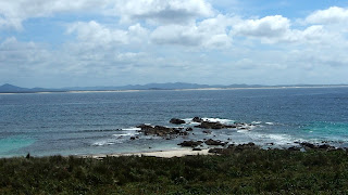
View to the mainland from Providence Bay and some fine rock formations.


 One of half a dozen not-too-shabby fisherman's shacks. 

 
One of the camping platforms. There are tether points for up to 3 tents per platform. The ecco friendly 'drop toilets' a little climb away.

 John , our adopted guide, checking out the waterfall in Esmerelda Cove.
It's your natural 'shower'. The water was really sweet!  

The Bloke following Jen across the rock platform.

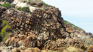
Eroded rock looking like a slumped brick wall.

 
Rewarding views

The Bloke declined going to the very top due to a heart condition. He's paranoid about snakes and we had to trek across a barely-defined path and on top of Shearwater (Mutton Bird) burrows. They are known to co-habit with snakes. He and I both felt that our hearts might unhinge our chests at anytime for the heavy beating! The burrows were everywhere although no birds were evident during the day. Night time was another story. We could hear the chicks mewing and the adults must have been attracted to our masthead light and continually crashed into our rigging until we turned it off and lit a lantern in our cockpit in lieu.

Esmerelda Bay in the foreground. 
Our yachts anchored in Coalshaft Bay beyond, out of the way of the NE wind.

On top of our part of the world today.