Live Track - Past 90 daysDistance Sailed to date - 15,383Nm
Download Email Maximum of 160 characters and you cannot include images, as this is a Short Message Service only. Download
Download our track Email us OffShore SMS us OffShore Download GoEast tracks

Wednesday, November 5, 2014

Changing moods at Wineglass Bay

Arriving as we did at Wineglass Bay in the dead of night, always meant that we'd be in for a big surprise at dawn. To begin with we had very conservatively anchored bang in the middle of the bay and were getting a fare bit of surge. Wobble, wobble. Relocating to a better position took a couple of goes as we sampled this position and that, eventually conceding that the nice tucked away area that we were favouring would ultimately have us standing on our keel as the tide ran out. So back to the wobble, wobble.

 Dawn - Day 1 - conclusion - It's a peach.

Azure water and white sandy beach.
Certainly no problem anchoring here and it's 3m almost to the beach.

It's so good, let's improve the view and get that dinghy down.

The world arrives for lunch.
It's pretty choppy by now so the passengers might experience lunch twice.

Off they go across the bay to look at more things.
This should give some perspective of the width.

 Rock your boat and away you go.

 Campers and bush walkers came and went in all weathers.

 Quite a peak.


 The clouds began to indicate something brewing.

The fishermen thought so too and anchored up next to us.

We watched and waited.

Even the gulls got a bit touchy.

After a night of blowing hard (25-30knots and gusting to 40), the rain came down!

Just happy to get here.
This guy appeared overnight and dropped anchor like we had in the heart of the bay.

And down it poured.
So much so that the dinghy was awash again. 
Just like it was in Streaky Bay. We are guessing around 100mm.

The folks at King Island bottle this stuff and sell it as 'Cloud Juice'.
It made the best tea....ever!
Relax, we had a bucket out to collect this - it's not from the dinghy!

 The rock faces gushed with waterfalls.
The tour boat didn't bother visiting today!

Tuesday, November 4, 2014

Leg 36 - Tomahawk Bay to Wineglass Bay

94 Nautical miles

The anchor came up at 07:20 after being well buried in sand. We hadn't shifted all night and the Anchor Watch program on the iPad confirmed this a heavily coloured crescent. It had been a rolly night but a weary sleep can cope with that.

We'd no sooner raised the anchor and pointed out past Tomahawk Island when I noticed a whale surface and then breach about 100m away. Wow! Our first whales on this trip. I don't mean just today or recently, I mean since leaving Mandurah last November! Of course we've seen lots of whales before, especially when we sailed to Shark Bay and back 3 years ago, but in over 2,000 nautical miles and 12 months we've not spotted a single one until now. By the time I got the camera we were moving away from the show and was clicking out of synch of the action. Darn!

 The best shot I could get after getting over the surprise of seeing the whale/s.

Not quite 'stupid o'clock' but certainly an early start. The tide lords dictate an ebb tide is what is needed to pass through Banks Strait and even getting there would be a whole lot easier going with the tide than against it. Tick tock, tick tock. It won't hurt to mention this again but Bass Strait is incredibly tidal. Eddystone Point is barely out of Bass Strait and has a tidal range of less than a metre. Inside Bass Strait the tidal range is 3m and the water fairly rips along. 

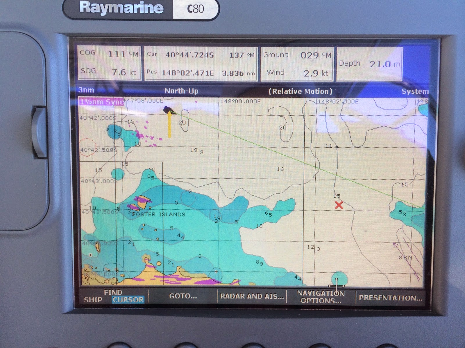
Yup - 7.6knots Speed Over Ground (SOG) with 2.9knots of wind!

There is a wind farm out on Cape Portland that is quite the biggest of any we've seen. I counted more than 50 turbines. We made it out to Banks Strait under motor. After the huge wind of the day before, the morning breeze was insufficient to get through the chute within the ebbing tide. Getting there was not negotiable. It was a very scenic run between Cape Portland and Swan Is with a view to Cape Barren Is and other islands of the Furneaux Group to our north. We'll visit them on our way back across Bass Strait next year. 

Turbines having a rest today after probably near blowing away their foundations yesterday.

There must be an explanation but why is it that on a lonely road you'll pass the only other car coming in the opposite direction on a bridge or some other restriction? Traveling as we have, through winter months and less common routes, we've encountered very little shipping, so logic is against the odds that we'd come the closest to any passing ship while passing through Banks Strait which is barely 2nm wide!

SC Kulanda passed us by at 6.9kn between Cape Portland and Swan Is.

A shameless selfie as proof of life.

We reached our planned destination for the day with a northerly wind and a southerly swell  of around 3m around lunchtime after our speedy transit through Banks Strait. Absolutely NOT what the Bloke was expecting. The Northerly yes; and in fact we were thrilled that it filled in as we popped out of the Strait and commenced a southward course. Unbelievable. We wouldn't have dared even script it. It was however strangely, predicted!

Odd looking rocks just north of Eddystone Point
Eddystone Point Lighthouse.

The 3m southerly swell was a game changer. What to do? What to do? We felt fresh enough and Eddystone was certainly presenting as untenable. Even without the swell it still looked awkward for wind changes. It's not like going to a different part of a bay, it required negotiating an ugly looking point. Not a Cape, but a nasty headland. Conditions for the next day would be stronger. In 14 or 15 hours we could be somewhere more suitable - our next planned destination! OK Wineglass Bay or bust. Conditions were suitable to get there - a northerly wind that should strengthen to allow us to sail without being too strong, a near full moon, a huge wide and protected throat to the bay entrance and a bay that was over 1nm wide when we got in. Neat! Here we go, here we go, here we go! 

The Bloke confessed to me later that the only boat that has been 'lost' on one of the Van Diemens Land circumnavigation/rally held every 2 years, has been at Eddystone Point. The yacht failed to negotiate the nasty hedland in bad conditions while attempting to get to a more favourable anchorage on the other side of the point. This fact certainly vindicated out thought process.

We motor sailed until we could sustain a minimum of 5kn (the Captain Paul cruising rule) and then sailed on into a fine and moonlit night past St Helens and Bicheno.  In fact, there seems to be small hamlets all down the coast of the Bay of Fires. The terrain is quite mountainous too. A very attractive backdrop for our passage.

Dusk

This is not a photo from the moon.
Motoring into Wineglass Bay at 02:00am Tuesday.
Clearly this does not capture the grandeur of the moment but check out the silhouette!

Sunday, November 2, 2014

Leg 35 - Beauty Point (TYC) to Tomahawk Bay

43 Nautical Miles

Honey, shall we go out in a gale? What kind of question is that!

After hiding away, first at Low Head, then at Dark Hollow and finally at the Tamar Yacht Club sheltering from one cold front followed by another; and yet another, it did look like we'd checked into the mythical  'Hotel California' where you can '...check out any time you like but you can never leave!' We'd gone to bed last night feeling quite glum and thinking it might be a fourth postponement and now next Thursday, before 'just maybe' it would be possible to go further. A morning viewing of Met-Eye suggested that although conditions were strong in the early part of the day, winds would be from the west. The wind would be from behind pushing us exactly in the direction we wished to go. What a nice change. The price would be the 'strength' but from behind. If you are moving forward at 6knots, the apparent wind is whatever it is less the 6 knots of movement. It was also meant yto lessen during the afternoon (although it didn't do so until sunset). Sounded OK and the best part was that once we'd be on anchor at Tomahawk Bay the wind would remain from the SW meaning that we would not be anchored on a lee shore. Golden! The possibility of good night sleep instead of an anchor watch. What's not to love?

The decision to just 'go' was made rapidly and independently. The Bloke was very gratified to see me preparing by the time he'd returned from the ablutions. Passage food had already been prepared mid-week when we thought Wednesday would be 'leaving day'. All good. We got organised, taking off all the extra lines we'd attached in readiness for the 'blows' we'd just sat through. (Tasmania had been swathed in RED on the computer wind predictions for the whole week - plenty of 50knot winds). By 10:30 we were motoring out past the hulks used by the Australian Maritime Training Centre and on our way, with the ebbing tide shortening our journey by 30mins. What a well oiled machine!

It wasn't long before Low Head and all the details on the shore with which we'd become familiar in the  preceding week started to become small as we were whisked away in a freshening wind on a mostly sunny day. That's when we began to hear a strange bellowing sound. It had us wondering for a few minutes before we recalled that the old Fog Horn at Low Head Lighthouse is sounded every Sunday at noon for tourists. It was loud when we heard it out to sea, heavens only knows how the operators coped when it was in regular use!


Part of the sound generating equipment.
As you can see, it's not insubstantial and you really can hear it from a long way.

It was certainly blew it's socks off today at 25-30knots with the occasional blast of 40 for good measure but it was perfectly OK and it wasn't long before we were piping down some swells at 10.5 knots! What a bobsled ride! We averaged 7.0 knots for the trip. The Bloke thought he's spare me the details of the actual wind velocity but I told him to cut it out because I know what the sea looks like at 20, 30 and 30+ knots. It is, what it is and pretending otherwise is for no purpose.
 
We began the day with just the headie up and as the wind freshened it was furled to the 3rd reefing marker and then successively until there was barely the lace in a pair of 'frilly knickers' flying. The only time it was a little hairy was rounding the top of Waterhouse Island. By this time the swell, (that infernal Bass Strait) tide and wind created an evil cocktail across the reef at the head of the island, kicking up the water so that I could see through the tops of the cresting waves before they came crashing down and sounding like a steam train. The Bloke was helming at this stage and was mightily encouraged to be in view of completely calm water in the lee of the Island if we could just stop from rounding up and get there! It helped a lot to just keep pointing the bow without focusing on what was going on behind. Trying to second guess if the next wave would shove Zofia's bum this way or that didn't help at all. If one wave knocked us off course the next one tapped us back again. Of course, time seemed frozen while we were in the thick of it but it probably only took 15 minutes to jibe and get around the top of the Island and into flat water. Phew.

Tomahawk Island

We chose to anchor inshore behind Tomahawk Island although the Cruising Guide suggested an anchorage beneath the Lighthouse as one commonly used by cruisers heading for the Furneaux Group. Good luck to them, we thought as we sailed right on past it! We wanted something a little more embracing even if it was described as potentially rolly. The assessment in the guide was spot on. Happily, the anchor snatched in like a beauty. No fuss. Time to unclench all those muscles that we suddenly noticed were tight and we were rocked away to a well earned sleep.

 
Sunset over Tomahawk settlement.

 Rum rations earned tonight.

Saturday, November 1, 2014

More about Low Head Pilot Station

The Tamar River is not so much a river as a flooded estuary. 70km from the ocean, the North Esk and South Esk Rivers merge at the city of Launceston before emptying into Bass Strait at Low Head.  It has a significant navigable channel of mostly over 40m depth and these days is used by shipping concerned with the woodchip, aluminium processing(Pacific Aluminium) and manganese (BHP Billiton) industries. Historically, shipping was possible all the way to Launceston but now with the increased size of cargo vessels, Bell Bay is the destination half way upstream and the river channels beyond have been allowed to silt up to shallower depths.

The Hebe Reef marker on western approach.

Looking up the Tamar from Low Head although the Bloke is looking out to sea.
We confirm that you CAN see sheep.

There has been a long history of marine Pilots in the Tamar River and in the earliest days of European settlement a Pilot Station and Lighthouse were established to assist vessels avoid the hazards and safely navigate into the restricted channel. The old Pilot Station and associated precinct of accommodation, school and church have been preserved and there is a Museum and Cafe for tourists.


 Some of the Pilot's houses are now used as holiday accommodation.
The 'village green' was used to corral livestock, often rescued from sinking ships.

 The original Hebe Reef nun buoy.
It is timber and constructed much the same as a barrel.
In the background are 2 lead-lighthouses to assist in safe night pilotage.

A closer look at various lead markers.

On the way to the Low Head lighthouse.

 
The lighthouse keepers house is now used as holiday accommodation.
It's very noisy at night because of the penguin colony nearby.

 
The Low Head lighthouse was visible from miles out to sea - even in the day.

The Low Head lighthouse is accompanied by another building that is no-longer in use - it houses a Fog Horn. The Fog Horn has been restored and is operated on Sundays by volunteers. It can be heard for 20nm out to sea. Since the advent of modern navigational equipment it is no longer required.
 

About 150m away from the lighthouse is a semaphore mast which was one of 5 similar towers used for relaying messages to George Town. Once decoded, signal flags were then used to relay necessary messages onwards to the Launceston Post Office. In it's day and before it was replaced by the electronic telegraph, messages could be sent and received in a matter of minutes. The messages might include such things as the sighting of a ship or a request for additional rowers to deliver a pilot to a ship and so on.

These days, the lighthouse is automated and the Pilots are dispatched in a powerful boat from the little marina at the Low Head Pilot Station. Given the strongly tidal conditions, even on a calm day it's hard to imagine how tough the oarsmen must have been to deliver the Pilots in all weathers. During our 3 days there, the modern Pilots went out only once.

Zofia on the floating public jetty and the Pilot boat on it's own jetty, all ready to go.